

So Reasonable! So Pure!
Ecuador is one of the smallest countries in South America. Located on the west coast and straddling the equator, Ecuador has a total area of about 280,000 square kilometers, which includes the Galápagos Islands. Roughly the size of the state of Colorado, Ecuador encompasses a wide range of natural formations and climates, from the desert like southern coast, to the snow-capped peaks of the Andes Mountains, to the plains of the Amazon River Basin.
Ecuador is bounded on the west by the Pacific Ocean, on the north by Colombia, and on the east and south by Peru. Ecuador continues to contest the boundary with Peru, which was established by the Protocol of Peace, Friendship, and Boundaries (Rio Protocol) of 1942 and ceded to Peru a large portion of territory, east of the Andes.
Ecuador – Natural Regions
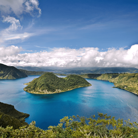
Ecuador is divided into three continental regions–Costa, Sierra, and Oriente–and one insular region–the Galápagos Islands. The continental regions extend the length of the country from north to south and are separated by the Andes Mountains. The Galápagos Islands, officially called the Archipiélago de Colón, are located 1,000 kilometers west of the Ecuadorian coast within 1 kilometer south of the equator.
The Costa, located between the Pacific Ocean and the Andes Mountains, consists of coastal lowlands, coastal mountains, and rolling hills that separate river valleys. The widest part of the region stretches 150 kilometers from Cabo San Lorenzo in the Province of Manabí to the foothills of the Andes Mountains. In the southern part of the Guayas Province, east of the Gulf of Guayaquil, the narrow coastal plain is only fifteen to twenty kilometers wide. The lowlands of the Costa do not exceed 200 meters in elevation, whereas the coastal mountains extend no higher than 1,000 meters. The coastal mountain chain, known as the Cordillera Costañera, divides the region into the Costa Externa, next to the coast, and the Costa Internal, next to the Andes. The Cordillera Costañera reaches from Esmeraldas in the north to Guayaquil in the south. North of Portoviejo in Manabí Province, the Cordillera Costañera loses its character as a mountain chain and becomes a series of hills and small mountains.


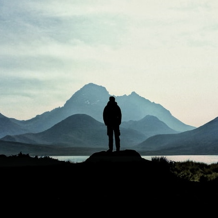
The Sierra consists of two major chains of the Andes mountains, known as the Cordillera Occidental (Western Chain) and Cordillera Oriental (Eastern Chain), and the intermontane basin or plateau between the two chains. Several transversal mountain spurs, known as nudos, cut across the plateau. The Nudo del Azuay, at 4,500 meters the highest of these transversal spurs, divides the Sierra into two subregions–the area of modern volcanism to the north and the area of ancient volcanism to the south. The former area consists of newer, higher mountains than those in the ancient volcanism section, which with time have eroded to lower levels.
The Sierra has at least twenty-two peaks over 4,200 meters in height. Of the two cordilleras, the Cordillera Oriental is wider and generally higher, with peaks averaging over 4,000 meters. The Cordillera Occidental, however, contains the highest point in Ecuador, which is the Mount Chimborazo at 6,267 meters. The Sierra also contains the highest point on the equator, Mount Cayambe at 5,790 meters.
The Sierra has at least thirty peaks of volcanic origin, including six still active. These peaks, which vary in width from 80 to 130 kilometers, are located in the area of modern volcanism known as the Avenue of the Volcanos. The most active volcano is Mount Sangay, 5,230 meters high. Although its last major outpouring of lava occurred in 1946, specialists consider Mount Sangay to be in a constant state of eruption because of fires and bubbling lava in its crater. Mount Cotopaxi, at 5,897 meters is the highest active volcano in the world, last erupted in 1877 and is now listed as “steaming.” Its crater is 800 meters in diameter. In addition to the other damage caused by eruptions, volcanos in the Sierra have melted snow caps, which in turn generate massive mudslides and avalanches. Earthquakes and tremors are also common in the region.


The intermontane plateau between the two cordilleras is divided by the nudos into roughly 10 basins, or hoyas, that range from 2,000 to 3,000 meters in altitude. The average altitude of the plateau is 2,650 meters.
The Oriente to the east of the Cordillera Oriental consists of two subregions: the Andean piedmont and the Eastern lowlands. The piedmont drops from a height of 3,353 meters to the featureless lowlands, which spread out at an altitude of 150 to 300 meters.
The Galápagos Islands consist of a chain of large, medium, and small islands that have a combined area of roughly 8,000 square kilometers. The largest island is the Isabela Island, also known as Albemarle Island, which is 120 kilometers long with an area of 4,275 square kilometers. All of the islands are of volcanic origin, and some have active cones. Santo Tomás, located on Isabela Island, is the highest peak of the Galápagos at 1,490 meters. Its crater is ten kilometers in diameter.
Ecuador – Rivers
Almost all of the rivers in Ecuador rise in the Sierra region and flow east toward the Amazon River or west toward the Pacific Ocean. The rivers rise from snowmelt at the edges of the snow-capped peaks or from the abundant precipitation that falls at higher elevations. In the Sierra region, the streams and rivers are narrow and flow rapidly over precipitous slopes. Rivers may slow and widen as they cross the Hoyas, yet become rapid again as they flow from the heights of the Andes to the lower elevations of the other regions. The highland rivers broaden as they enter more level areas of the Costa and the Oriente.
In the Costa region, the Costa Externa has mostly intermittent rivers that are fed by constant rains from December through May and become empty riverbeds during the dry season. The few exceptions are the longer, perennial rivers that flow throughout the Costa Externa from the Costa Internal and the Sierra on their way to the Pacific Ocean. The Costa Internal, by contrast, is crossed by perennial rivers that may flood during the rainy season, sometimes forming swamps.


The second major Costa river system–the Esmeraldas–rises in the Hoya de Quito in the Sierra as the Guayllabamba River flows westward to empty into the Pacific Ocean near the city of Esmeraldas. The Esmeraldas River is 320 kilometers long and has a 20,000-square-kilometer drainage basin.
Major rivers in the Oriente include the Pastaza, Napo, and Putumayo. The Pastaza is formed by the confluence of the Chambo and the Patate rivers, both of which rise in the Sierra. The Pastaza includes the Agoyan waterfall, which at sixty-one meters is the highest waterfall in Ecuador. The Napo rises near Mount Cotopaxi and is the major river used for transportation in the Eastern lowlands. The Napo ranges in width from 500 to 1,800 meters. In its upper reaches, the Napo flows rapidly until the confluence with one of its major tributaries, the Coca River, where it slows and levels off. The Putumayo forms part of the border with Colombia. All of these rivers flow into the Amazon River. The Galápagos Islands have no significant rivers. Several of the larger islands, however, have freshwater springs.

Buy Now and receive over $50,000 of Benefits FREE!
FREE family golf membership (initiation fee) valued at $30,000 FOUR energy-efficient home appliances
FREE solar thermal hot water
FREE reverse osmosis water treatment system
FREE 5kW solar electric system valued at $15,000
FREE outdoor kitchen (houses only)
FULL access and use of Ceibo Valley Beach Club
FULL access to all Ceibo Valley Fitness Centers
*For a limited time only, Ceibo Valley reserves the right to amend or end this promotion at any time.